Explore Neighbourhoods Through Profiles:
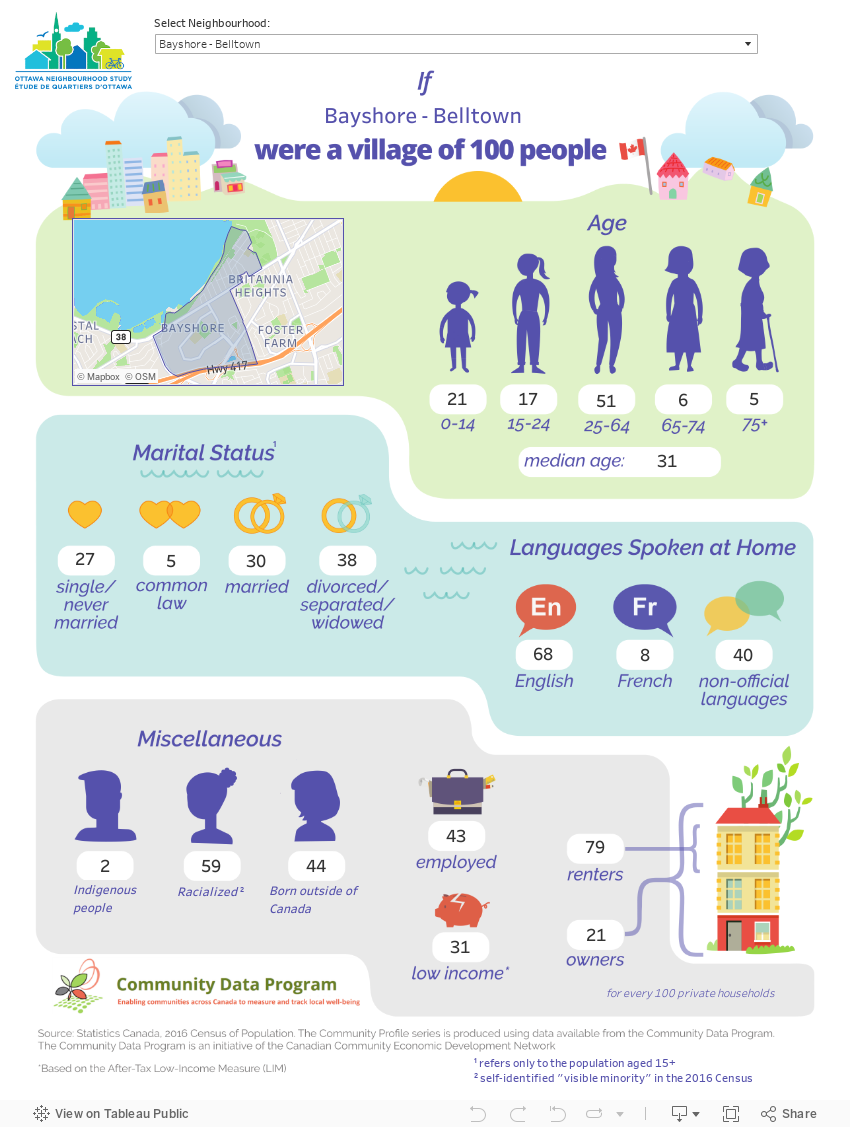
Explore Your Neighbourhood as a Village of 100
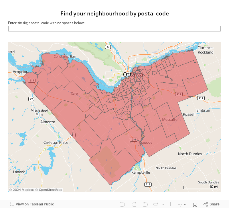
Find Your Neighbourhood by Postal Code
Explore Your Neighbourhood’s Data Profile
Bayshore is a community that was first built in the mid-1960s by the Minto Group, with more townhomes and apartment complexes added in the 1970s and 1980s. The main street in Bayshore is Woodridge Crescent with Bayshore Station as the major bus transit station. The main attraction is the Bayshore Shopping …
Explore
Explore
Beacon Hill South-Cardinal Heights is bounded by Montreal Road to the north, the Queensway to the east, and Blair Road to the west. Beacon Hill was originally named after a lighthouse in the Ottawa River that was visible from the neighbourhood. While the lighthouse is no longer there, the foundation …
Explore
Explore
Beaverbrook is one of the original neighbourhoods of the former city of Ottawa. The area remained mainly agricultural until the 1960s, when it was developed from rural land that was acquired by Bill Teron. The neighbourhood was built using a model community approach, which made Beaverbrook into an independent neighbourhood …
Explore
Explore
Welcome to Beechwood Cemetery! …
Explore
Explore
Bells Corners East is bounded by the Greenbelt to the north and south, Highway 416 to the east and Moodie Drive to the west. Originally named after Hugh Bell, Bells Corners East was mainly rural until the 1900s. By the 1950s, the neighbourhood had become a commercial centre for the …
Explore
Explore
Bells Corners West is surrounded by the Greenbelt to the north, south, and west, and is bounded by Moodie Drive to the east. Originally named after Hugh Bell, Bells Corners West was mainly rural until the 1900s. By the 1950s, the neighbourhood had become a commercial centre for the outlying …
Explore
Explore
This neighbourhood is one of the oldest communities in Ottawa. The area was originally a village that was named after Bradish Billing, who settled in the area in 1812. The bridge “Billings Bridge” was built in 1830, and later remodeled in 1916 to the structure that exists today. The neighbourhood …
Explore
Explore
This neighbourhood was named after Robert Blackburn, who was a Member of Parliament for Russell in 1858. In 1956, the area surrounding Blackburn Hamlet was acquired by the National Capital Commission and used to establish the Greenbelt …
Explore
Explore
Welcome to Borden Farm – Fisher Glen! …
Explore
Explore
Braemar Park-Bel Air Heights-Copeland Park is bounded by the Queensway to the north, Baseline Road to the south, Clyde Avenue to the east, and Woodroffe Avenue to the west. These communities were built primarily in the late 1950s and early 1960s although Minto built Castle Hill, a 21-storey apartment building, …
Explore
Explore
Briar Green-Leslie Park is bounded by Baseline Road to the north, CN Railway to the south, Centrepointe community to the east, and Highway 416 to the west …
Explore
Explore
Bridlewood-Emerald Meadows is bounded by the Greenbelt to the north, Hope Side Road to the south, the Greenbelt and Richmond Road to the east and Eagleson Road to the west. This area was first settled in the early 19th century as part of the Township of March. The area remained …
Explore
Explore
Britannia is bounded by the Ottawa River to the north, Richmond Road/Carling Avenue to the south, the Sir John A. MacDonald Parkway to the east, and Greenview Avenue to the west. The area has long enjoyed a reputation in the city for its excellent river access, parklands, proximity to the …
Explore
Explore
Welcome to Brookside – Briarbrook – Morgan’s Grant! …
Explore
Explore
This neighbourhood is one of the most recognizable and historic areas in the city, and is considered to be the birthplace of Ottawa. Established by Lieutenant Colonel John By in 1826, Byward Market was developed to accommodate a large public market and gathering place for residents. There has been a …
Explore
Explore

Cardinal Creek Village is a relatively new subdivision in east Orléans which is expected to grow to a community of over 3,000 homes. The developer (Tamarack Homes) invited prospective residents to “discover a land rich in heritage and lush with vistas … a rolling landscape of walking trails and rugged …
Explore
Explore
Carleton Heights-Rideauview is bounded by Heron Road to the north, the Rideau River to the south and east, and Fisher Avenue to the west. The neighbourhood includes the communities of Rideauview, Carleton Heights and Debra-Dynes …
Explore
Explore
The Carleton University neighbourhood is bounded by Rideau Canal to the west and north, Bronson Avenue to the east, and Rideau River to the south. Carleton U currently houses more than 22,000 undergraduate and more than 3,000 postgraduate students. Carleton University is named after the former Carleton County, Ontario, which …
Explore
Explore
Carlington is bounded by Carling Avenue to the north, Kingston Avenue and Caldwell Avenue to the south, Fisher Avenue to the east, and Maitland to the west. This neighborhood contains a small number of older homes that were built after WWII to accommodate returning veterans. These homes were known as …
Explore
Explore
Welcome to Carlingwood West – Glabar Park – McKellar Heights! …
Explore
Explore
Carp, a village to the west of Ottawa, was named after the Carp River that runs through the majority of the area. This river initially took its name due to the overwhelming amount of the carp fish that lived within it (fish said by early French explorers to be suckers …
Explore
Explore
Carson Grove is considered a mature neighbourhood that is mainly residential but is also home to the federal government’s tech intelligence agency, the Communications Security Establishment, at 1929 Ogilvie Rd. There is an active community association …
Explore
Explore
Beinvenue à Centre-Ville Ouest …
Explore
Explore
The Centrepointe neighbourhood lies within the boundary of Baseline Road to the north, just south of Pineview, Mapleview and Wycliffe Crescents, Woodroffe to the east, and just west of Marble Arch Crescent. This neighbourhood is a newer residential subdivision that was developed in 1985. Previously farmland, it was purchased by …
Explore
Explore
Centretown is bounded by the Ottawa River to the north, the Queensway to the south, Queen Elizabeth Drive and the Rideau Canal to the east, and Bronson Avenue to the west. This large neighbourhood comprises a unique blend of residential and commercial areas, and includes a large government sector within …
Explore
Explore
This neighbourhood is one of the outer suburban areas of Ottawa. Chapel Hill North was originally part of the City of Gloucester, which was amalgamated with the City of Ottawa in 2001. Orléans in general has seen steady growth since the 1970s. Similar to other neighbourhoods in the National Capital …
Explore
Explore
Chapel Hill South is bounded by Innes Road to the north, Mer Bleue to the east, and the Greenbelt to the south and west. This neighbourhood is one of the outer suburban areas of Ottawa. Chapel Hill was originally part of the City of Gloucester, which was amalgamated with the …
Explore
Explore
Welcome to Chapman Mills! …
Explore
Explore
Chatelaine Village is bounded by the Ottawa River to the north, the Queensway to the south, Trim Road to the east, and Champlain Street to the west and includes Queenswood Village. Orléans in general has seen steady growth since the 1970s. Similar to other neighbourhoods in the National Capital Region’s …
Explore
Explore
Crestview-Meadowlands is bounded by Baseline Road to the north, Parkside Crescent, Glenmanor Drive, Hillmount Crescent, Whitehill Drive and Sullivan Avenue to the south, Merivale Road to the east and Woodroffe Avenue to the west and includes the communities of Cityview, Meadowlands and Crestview …
Explore
Explore
Civic Hospital–Central Park is bounded by the Queensway to the north, Baseline Road to the southwest and Dynes Road to the southeast, Dow’s Lake and the Rideau Canal to the east, and Clyde Avenue to the west. This neighbourhood is named after The Ottawa Hospital’s Civic campus that is located …
Explore
Explore
Constance Bay was named by French Fur Traders after Simon Constant who was a member of the Algonquin First Nation and who was in the area before white settlers arrived. The neighbourhood consists of about 30% cottage/seasonal housing; 70% year round. The community surrounds the Torbolton Forest (a 147 Hectare …
Explore
Explore
Convent Glen – Orléans Wood covers the north-west area of Orléans. The community is bordered by the National Capital Greenbelt to the west, the Ottawa River to the north, Champlain St. to the east and St. Joseph Blvd. to the south. The community is served by the Jeanne d’Arc Transitway …
Explore
Explore
Corkery was founded by approximately 100 Irish families from County Cork immigrating to the region in the early 19th century, locally known as the “Peter Robinson settlers”. The first church in the village was built in 1837, although some reports put it at 1824 which would make it the second-oldest …
Explore
Explore
This neighbourhood is divided into two sections by Moodie Drive. The Western section, Crystal Bay, is bounded by the Ottawa River to the north, Carling Avenue to the south, and Rifle Road to the west. The Eastern section, which includes the communities of Crystal Beach and Lakeview Park, is bounded …
Explore
Explore
This community is considered to be a large village that was part of the historic Township of Cumberland. While it may be confused with the short lived City of Cumberland, the community of Cumberland became part of the eastern part of the City of Ottawa in 2001 …
Explore
Explore
The Dunrobin Community Association defines the community boundaries as Murphy Sideroad, Constance Lake Road and Berry Sideroad on the south, the Ottawa River to the east, a line following Limestone Road to Kinburn Sideroad to Stonecrest Road to Thomas A. Dolan Parkway to Marchhurst Road, and on the north by …
Explore
Explore
Welcome to East Industrial! …
Explore
Explore
The rural neighbourhood of Edwards-Carlsbad Springs includes the communities of Carlsbad Springs, Edwards, Piperville and Ramsayville. The boundaries are described as Ramsayville Road (W), Milton Road & Frank Kenny Road (E), Ridge Road (N), and Mitch Owens Road (S). Edwards is a dispersed rural community at the headwaters of Bear Brook and …
Explore
Explore
Welcome to Elmvale – Canterbury! …
Explore
Explore
Welcome to Emerald Woods – Sawmill Creek! Emerald Woods-Sawmill Creek is bounded just south of Hunt Club Road to the north, Lester Road to the south, Albion road to the east and just west of Millstream Way and Mac Street. The neighbourhood includes the communities of Sawmill Creek and Emerald …
Explore
Explore
Welcome to Fallingbrook! …
Explore
Explore
Welcome to Findlay Creek! …
Explore
Explore
The Glebe-Dow’s Lake neighbourhood is bounded by the Queensway to the north, Queen Elizabeth Drive to the south and east, Preston Street to the southwest, and Bronson Avenue to the northwest and includes the communities of Dows Lake, Glebe Annex and The Glebe. The Glebe was initially established in 1837, …
Explore
Explore
The Glen Cairn-Kanata South area is bounded by Hazeldean Road to the north, Fernbank Road to the south, Eagleson Road to the east, and Terry Fox Drive to the west and south. It includes the communities of Glen Cairn, Bridlewood Trails, Trailwest and Kanata South Business Park. One of Kanata’s …
Explore
Explore
Greenboro East is bounded by Johnston Road to the north, Conroy Road to the east, Albion Road to the west, and just south of Hunt Club Road …
Explore
Explore
Hawthorne Meadows-Sheffield Glen is bounded by Lancaster Road on the north and east, Walkley Road on the south, and St-Laurent Blvd. to the west. Considered part of Elmvale Acres, this once agricultural-now mainly residential land was part of the township of Gloucester before its amalgamation with the City of Ottawa …
Explore
Explore
Hintonburg-Mechanicsville is bounded by the Ottawa River on the north, Highway 417 on the south, and the O-train line on the East. Its western border includes Parkdale Ave north of Scott St. and Holland Ave. south of Scott St. The neighbourhood includes the communities of Tunney’s Pasture, Mechanicsville, Wellington Towers, …
Explore
Explore
Hunt Club-Ottawa Airport is bounded by Hunt Club Road and Uplands Drive on the north, the Greenbelt to the south, the Airport Parkway to the east and Riverside Drive to the west. The Hunt Club neighbourhoods were initially part of the Gloucester Township before their amalgamation to Ottawa in 2001 …
Explore
Explore
Hunt Club East-Western Community is bounded by the Ottawa-Carleton Railroad to the north, Hunt Club Road to the south, the O-Train line to the east and Uplands Drive to the west. The Hunt Club neighbourhoods were initially part of the Gloucester Township before their amalgamation with Ottawa in 2001. The …
Explore
Explore
Hunt Club Park is bounded by Johnston Road-Blohm Drive-Hunterswood Crescent on the north, Hunt Club Road on the south, Hawthorne Road on the east and Conroy Road to the west. The Hunt Club neighbourhoods were initially part of the Gloucester Township before their amalgamation to Ottawa in 2001. The area …
Explore
Explore
Welcome to Hunt Club South Industrial! …
Explore
Explore
Hunt Club Upper-Blossom Park-Timbermill is bounded by Hunt Club Road to the north, Lester Road to the south, Conroy Road to the east, and Albion Road to the West. This neighbourhood was originally part of the City of Gloucester until its amalgamation with the City of Ottawa in 2001. This …
Explore
Explore
Welcome to Hunt Club Woods – Quintarra – Revelstoke! …
Explore
Explore
Iris is bounded by the Highway 417 on the north and Baseline Road on the south. To the east of Iris is Woodroffe Avenue and to the west lies Greenbank Road. The neighbourhood includes the communities of Kenson Park, Parkway Park, and Pinecrest Terrace …
Explore
Explore
Wellington Village neighbourhood is bound by the Ottawa River on the north, Highway 417 on the south, Parkdale Avenue (to the north of Scott Street) and Holland Avenue on the east, and Island Park Drive to the west. When using this profile to help inform planning decisions, users need to …
Explore
Explore
Welcome to Kanata Lakes – Arcardia! …
Explore
Explore
Katimavik-Hazeldean is bounded by Highway 417 on the north, Hazeldean Road on the south, Eagleson Road on the East, and Terry Fox Drive to the west. This neighbourhood was one of Kanata’s original neighbourhoods, and dates back to the 1960s. The spirit of the community started with developer Bill Connelly adding …
Explore
Explore
Welcome to Laurentian! …
Explore
Explore
Welcome to Lebreton Development! …
Explore
Explore
Welcome to Ledbury – Heron Gate – Ridgemont! …
Explore
Explore
Welcome to Lindenlea – New Edinburgh! …
Explore
Explore
Lowertown is bounded by the Rideau River to both the north and the east. Daly-Besserer-Rideau Streets lay on the southern border, and King Edward Avenue lies to the west. The neighbourhood includes the communities of Beausejour, Beausoleil, Charlotte, and Macdonald Manor. Originally a cedar swamp on the lower of two …
Explore
Explore
Welcome to Manor Park! Manor Park is bound by the River to the North, Aviation Parkway to the East, and Montreal Road to the South. The West boundary is along Birch Ave (for the northern half of the neighbourhood) and along St. Laurent Blvd (for the southern half), joined by …
Explore
Explore
Bienvenue à Manor Park! Manor Park est délimité par la Rivière au nord, la promenade de l’Aviation à l’est et le chemin Montréal au sud. La limite ouest est le long de l’avenue Birch (pour la moitié nord du quartier) et le long du boulevard Saint-Laurent (pour la moitié sud), …
Explore
Explore
Manotick straddles the Rideau River between Rideau Road to the north and Century Road/First Line/Roger Stevens Drive to the south. The eastern boundary is Dozois Road/Gough Road/Manotick Station Road and to the west is Veterans Memorial Highway (Hwy 416). The neighbourhood includes the communities of Manotick Village, Long Island, Colony …
Explore
Explore
This neighbourhood includes the communities of Marlborough, Pierces Corners, Malakoff, and Burritts Rapids, one of the first settlements on the Rideau, predating the Canal itself. The village of Marlborough is located at the intersection of Pierce Road and Malakoff Road. Also included is Marlborough Forest, one of the most significant …
Explore
Explore
The neighbourhood that encompasses the communities of Merivale Gardens, Grenfell Glen, Pineglen and Country Place is bounded to the north by Hunt Club West, Macfarlane and Deer Lane Avenue and to the south by Black Rapids Creek. Both Greenside Avenue and Parmalea Crescent lay on the eastern border, while Woodroffe …
Explore
Explore
Metcalfe is bounded by Mitch Owens Road on the north, Belmeade Road on the south, and Boundary Road on the east. the Western boundary is described by John Quinn, Snake Island , and Fifth Line Roads. The neighbourhood includes the village of Metcalfe and the dispersed rural community of Marionville …
Explore
Explore
Munster – Ashton is bounded to the north by McArton, Spruce Ridge, Jinkinsin, Lucas, Flewellyn, Huntley, Fallowfield, Shea, Garvin, Eagleson, O’Keefe Court, Spring Cress and Cedarhill Roads. The Rideau River is to the south. To the east lies McCordick, Carsonby, 3rd Line, Barnsdale and Cedarview Roads. To the west lies …
Explore
Explore
Welcome to Navan – Sarsfield! …
Explore
Explore
This area was first settled in 1846 by Scottish and English settlers. Some of those original settlers’ descendants continue to live in the neighbourhood today. By 1866, the community was a post village of the township of North Gower situated on Stephens’ Creek, 6 miles from Osgoode Station on the …
Explore
Explore
Welcome to Notre-Dame Cemetery! …
Explore
Explore
Old Barrhaven East is bounded by Fallowfield Road to the north, Strandherd Road to the south, Greenbank Road to the east, and the CN rail line to the west. Established in the 1960s, Barrhaven was one of a group of new suburban areas built across the Ottawa Greenbelt. The area, …
Explore
Explore
Old Barrhaven West is bounded by Fallowfield Road to the north, Strandherd Road to the west, and the CN rail line to the east. Established in the 1960s, Barrhaven was one of a group of new suburban areas built across the Ottawa Greenbelt. The area, owned by Mel Barr, was …
Explore
Explore
Old Ottawa East is bounded by the Queensway and Nicholas Street to the north, the Rideau River to the east, Avenue Road to the south, and the Rideau Canal to the west. Old Ottawa East was originally the suburban community of Archville, and was incorporated as the village of Ottawa …
Explore
Explore
Old Ottawa South is situated between two waterways: the Rideau Canal to the North and the Rideau River to the East and South. It is bounded by Bronson Avenue to the West and by Avenue Road to the East. The neighbourhood includes the community of Rideau Gardens. Old Ottawa South …
Explore
Explore
Welcome to Orléans Industrial! …
Explore
Explore
Welcome to Orléans Village – Chateauneuf! …
Explore
Explore
The neighbourhood of Osgoode-Vernon includes the Village of Osgoode and the communities of Vernon, Sabourins Crossing, Reids Mills, and Dalmeny. Originally called Osgoode Station, the name of what is now an official Village within the amalgamated City of Ottawa was shortened to Osgoode in 1962. The Osgoode Village Story: A …
Explore
Explore
Welcome to Overbrook – McArthur! …
Explore
Explore
The Parkwood Hills neighbourhood stretches along both sides of Meadowlands Drive and south to Tiverton Drive, and includes the area south of Deerpark and west of Fisher Avenue, and the area defined by Meadowlands-Grant Caren-Bowhill-Hilhurst-Chesterton. This is a planned mixed-dwelling suburban community with apartment blocks, townhouses and an assortment of …
Explore
Explore
Pineview is bounded by Highway 417 on the north, Innes Road on the south, Blair Road on the east, and Cyrville Road to the west. Prior to the neighbourhood’s amalgamation to the City of Ottawa, Pineview was part of the city of Gloucester. photo by: @PineviewOttawa …
Explore
Explore
The neighbourhood of Playfair Park—Lynda Park—Guildwood Estates is described by Smyth Road to the north, Heron Road and Walkley Road to the south, Ryder-Featherston-Delmar to the east, and Parkland-Lynda Lane to the west. The neighbourhood includes the communities of Playfair Park, Lynda Park, Guildwood Estates, Canterbury, and Urbandale …
Explore
Explore
Welcome to Portobello South! …
Explore
Explore
Qualicum – Redwood Park is bounded by Highway 417 on the north, Baseline Road on the south, Greenbank Road and Draper Avenue on the east, and Richmond Road to the west. The neighbourhood includes the communities of Qualicum, Redwood Park, and Morrison Gardens …
Explore
Explore
Welcome to Queenswood Heights! …
Explore
Explore
Welcome to Rideau Crest – Davidson Heights! …
Explore
Explore
Riverside Park is bounded by the Rideau River to the north and west, Walkley Road to the south, and the Airport Parkway and the O-Train line to the east …
Explore
Explore
Riverside South-Leitrim is bounded by Leitrim Road to the north and Rideau Road to the south, Bowesville Road to the east and the Rideau River to the west. This is a suburban neighbourhood located in the former City of Gloucester just southwest of Ottawa Macdonald-Cartier International Airport. The neighbourhood includes …
Explore
Explore
The Village of Rockcliffe Park is noted for the beauty of its natural setting, green spaces and heritage that date back to the original division of the area. In 1864, Thomas Coltrin Keefer produced his subdivision plan for part of the estate of his late father-in-law – Thomas McKay. This …
Explore
Explore
Rothwell Heights-Beacon Hill North is bounded by the Ottawa River to the north, Montreal Road to the south, Green’s Creek to the east, and Blair Road to the west …
Explore
Explore
Sandy Hill is bounded by Rideau Street to the north, Highway 417 and the Transitway to the south, Rideau River to the east, and the Rideau Canal to the west. This neighbourhood includes the community of Strathcona Heights and the University of Ottawa. The neighbourhood was previously described by ONS …
Explore
Explore
Welcome to Skyline – Fisher Heights! …
Explore
Explore
South Keys – Greenboro West is bounded by the Ottawa Carleton Railroad-Holly Lane-Walkley Road on the north. To the south is Hunt Club – Albion – Tapiola – Johnston Road. Conroy Road is to the east and the O-Train line is to the west …
Explore
Explore
Welcome to Stittsville! photo by: @Mallory.Fay …
Explore
Explore
Welcome to Stonebridge – Half Moon Bay – Heart’s Desire! …
Explore
Explore
Tanglewood is bounded by Norice, Sullivan, Parkside, and Glenmanor Drive on the north, West Hunt Club Road on the south, Merivale Road to the east, and Woodroffe Avenue to the west. The neighbourhood includes the community of Hillsdale …
Explore
Explore
This neighbourhood was part of the City of Nepean prior to its amalgamation with the City of Ottawa in 2001 …
Explore
Explore
Welcome to Vanier North! …
Explore
Explore
Welcome to Vanier South! …
Explore
Explore
Welcome to Wateridge Village! …
Explore
Explore
Welcome to West Centretown! …
Explore
Explore
The neighbourhood of Westboro is bounded by the Ottawa River on the north, and Highway 417 and Carling Avenue on the south, Island Park Drive to the east, and Fraser Avenue to the west. The neighbourhood includes the communities of Westboro Village, Westboro Beach, Golden Manor, Dovercourt, Hampton Court, and …
Explore
Explore
Development in Whitehaven-Queensway Terrace began in the 1950s and lasted throughout the 1960s on agricultural land known as ‘Fox Farm’. The land was originally divided into fairly large lots, most of which were split further over the years. However, some of the original, larger homes still remain in the neighbourhood …
Explore
Explore
Before the amalgamation to the City of Ottawa, these neighbourhoods were part of the City of Nepean. Craig Henry, now a mature community, was built primarily in the 1970s on land that previously belonged to the Craig Henry farm, and was developed by Jack Aaron …
Explore
Explore
Tweet a photo of your neighbourhood to @ONS_EQO to have it featured on the profile page!